

Advice For A GPS.
Topic 29169 | Page 1

I have had good use with the Rand Mcnally GPS units. Started with the TND 730, then got the TND 740 when those came out three years ago. The newest upgrade is the TND 750.
You do not have to get one with all the bells and whistles for it to function just fine at it's intended purpose.
Every GPS will give you incorrect information at times, so it's only another helpful tool, not an "always right absolute". A current paper Rand Mcnally paper Truckers Atlas is the best guide.
HOS:
Hours Of Service
HOS refers to the logbook hours of service regulations.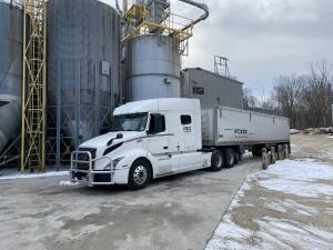
I’m probably one of the few who doesn’t own one. Granted, I do have the Co Pilot app on my phone but I only use it in reference to my road atlas. I think it’s more important to know how to plot your route, learn roads and alternate routes instead of relying on a tool which will often get you lost. It doesn’t take much longer to do it “the old fashioned way” and will only make you better in the long run.

I run a much smaller area so I'm familiar with the routes I need for the most part. I usually just run google maps to alert me to any delays and if anybody flags a stretch for something in the road. I also use it in satellite view to look at my destination to know what I'm facing when I arrive. Lately it seems people are intentionally marking a speed trap or debris in the road every 5 miles just to be a jerk.
The problem most drivers run into with GPS is blindly following it and getting into a pickle. It's a helpful tool to alert you to delays and closures due to accidents but it's still best to pull off and cross reference your atlas if you're taken off your planned route.
OWI:
Operating While Intoxicated
Good to hear from ya' from the road, OptiMan... I wrote you a supportive send-off post bemoaning the end of your diary, along with others previously (since then I got in with Schneider(!) so the co-teaming part is partly moot now); not sure if you had time to read your fan support there... S'gotta be crazy busy since you went to orientation, especially on top of keeping the diary. But you're doing what I'd hoped, checking in from the road, with a need you and others of us can hopefully learn from. I too have been wondering about what the current-best navigation tool is, and now I know to be sure to get that atlas ASAP...ya'd think all the training centers would sell 'em (not just boots like some do) or give us one, in addition to the guidance to the very best GPS system for their own drivers to use.
Key Q: Does anyone out there have a model that does NOT lead you astray more than a negligible amount? (Not make so many high-tech mistakes...yeah I know garbage in, garbage out is the limiter here, but still...) Sounds like so far no one has said that DOESN'T happen enough to them to render their GPS semi-non-reliable. From this distance, it seems like an occasional nightmare that could be MOSTLY solved by some sort of doubtful-data-detection feature, based on the human common-sense principle of 'when there's a possibility of doubt on a given route/destination, err on the side of caution'. In this case, it'd simply flash a warning to check your mappage cuz there MIGHT be a problem with a given piece of guidance, rather than risk defaulting to undetectably erroneous information which can be worse than useless. Software that could roughly assess the relative degree of certainty in its data.
Meantime, hope you let us know how it turns out...be safe man...and all of ya'll out there!
SAP:
Substance Abuse Professional
The Substance Abuse Professional (SAP) is a person who evaluates employees who have violated a DOT drug and alcohol program regulation and makes recommendations concerning education, treatment, follow-up testing, and aftercare.

I really like my Garmin 785 LMT-S with the dash cam for the following reasons:
1. Phone connectivity.
a. The Garmin Smarthphone Link connects the Garmin GPS to my phone. This gives me real time traffic information and the Garmin will warm me of traffic just like Google maps. Also, with the real time traffic, it adjusts my "arrive in" time. More on that below.
b. This also allows me to "send" my destination directly from my phone to my GPS. I find the address on Goolge maps, then choose "share" from Google maps. Then select Garmin Smart phone link. And it sends it to my phone. I can also "drop a pin" to the specific location. For example, Caterpillar of Morton, Illinois, is a big place. And address for the GPS will take you to the general location, but there are several entrances that say "no trucks." So where do you enter? Look at Google maps and the satellite. See the pictures below:
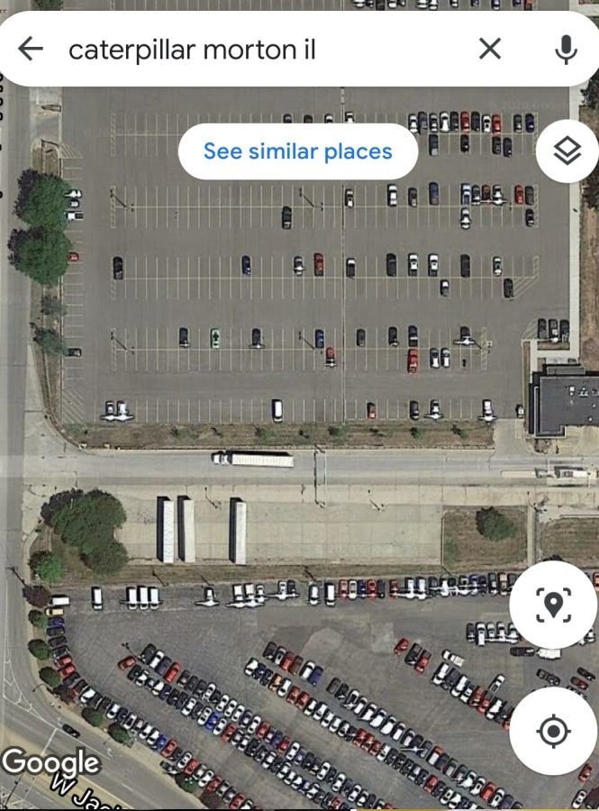
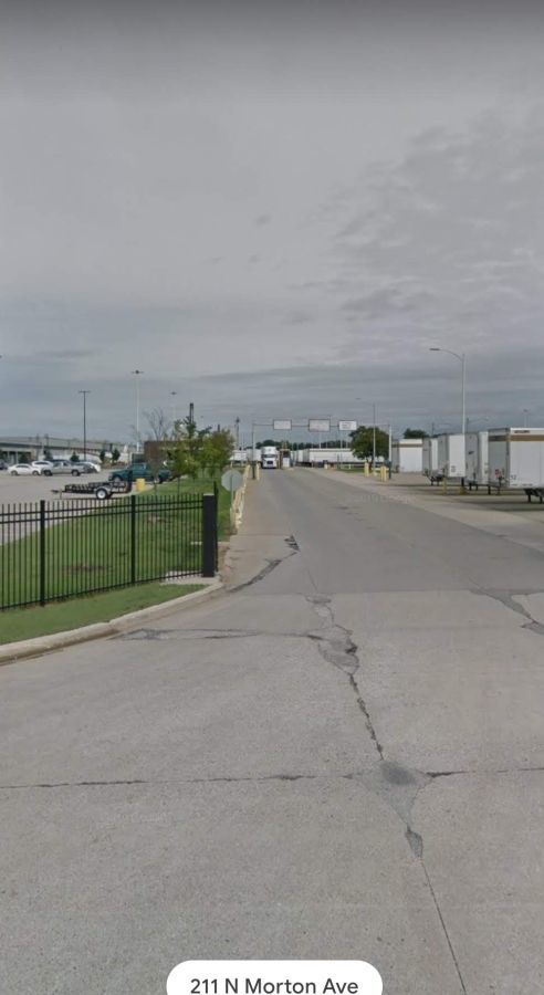
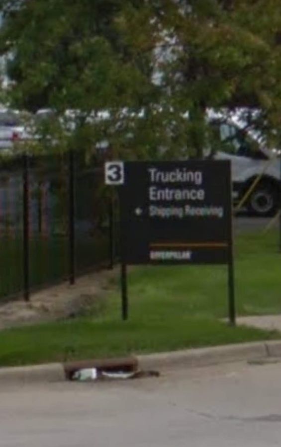
Now that I know exactly which entrance, I "drop a pin" by long pressing on the truck entrance. I "send" that to my GPS and it will take you exactly to the truck entrance.
2. Up a head feature.
My Garmin has an "up ahead" feature that tells me all the truck stops, truck parking, and Walmarts specifically on my route. It will also tell me how many parking spaces each truck stop or rest area has. Not how many that are open, but how many total. My trip planning basically consists of looking at what is ahead with about two to three hours left on my clock.
3. Arrive in time.
My Garmin tells me how long it will take me to get to my selected destination. And it's pretty accurate. As I mentioned, it factors in traffic delay. It is so accurate that I will choose, and make, a truck stop that my Garmin says I will arrive in 2 hours and 20 minutes, when I only have 2 hours and 30 minutes of my clock.
OWI:
Operating While Intoxicated
OOS:
When a violation by either a driver or company is confirmed, an out-of-service order removes either the driver or the vehicle from the roadway until the violation is corrected.

I didnt even buy a GPS for 18 months. Buy an atlas and learn the highways. Get a truckers guide book and use them together to plan a route. That way when you do get a GPS you wont rely on it but utilize it as the tool it is.
Also...3 GPS on the same dash can take you 3 different ways. My trainee recently learned that. Use the atlas to avoid non truck routes and low clearances.
I use a Samsung Galaxy Tab E8 16gb T377A, check it our on amazon for around $125 +\-. Way cheaper than a Garmin or Lowrance. It is durable and has a nice big 8" Screen. It does not need to be connected to wifi for the gps to work. Check it out at amazon for around $100 +/- . Then use whatever map app you want. I like GAIA for offroad and google maps for on road. For my offroad prerunner I use the Samsung Galaxy Active 2..
I use a Samsung Galaxy Tab E8 16gb T377A, check it our on amazon for around $125 +\-. Way cheaper than a Garmin or Lowrance. It is durable and has a nice big 8" Screen. It does not need to be connected to wifi for the gps to work. Check it out at amazon for around $100 +/- . Then use whatever map app you want. I like GAIA for offroad and google maps for on road. For my offroad prerunner I use the Samsung Galaxy Active 2..
But google maps and other non truck routing will get you in big big trouble. People have followed GPS onto beaches, the Atlantic City boardwalk, into lakes, onto historical bridges that were destroyed, crashed into low bridges
NEVER EVER follow a GPS blindly without checking an atlas for your truck size and height
Oklahoma has an infamous "shark bridge". It got its name from the countless trucks it has "eaten" due to driver error.
Go google that. Amazing stuff
Kearsey, my bad. I thought the question was asking for a recommendation for which gps unit people are using, not about the accuracy of a particular app or if a gps alone was trustworthy..
New Reply:
New! Check out our help videos for a better understanding of our forum features


Preview:


Why Join Trucking Truth?
- The High Road Training Program
- The High Road Article Series
- The Friendliest Trucker's Forum Ever!
- Email Updates When New Articles Are Posted
Apply For Paid CDL Training Through TruckingTruth
Did you know you can fill out one quick form here on TruckingTruth and apply to several companies at once for paid CDL training? Seriously! The application only takes one minute. You will speak with recruiters today. There is no obligation whatsoever. Learn more and apply here:
 TT On Facebook
Hey guys, so right now I'm out with my trainer and just getting together a list of things to get to outfit my truck when I get it. Now, I will be team driving so I know I can split the cost. Right now I'm just looking to get some advice on a GPS. I've been looking around and a lot of good ratings for a Garmin, but I'm stuck on getting a Rand McNally and I was looking at the DriverPro 8 2 but haven't been able to find any kind of reviews on that one. There are some good reviews on the DriverPro 8, just wondering what your suggestion would be and why.
Thank You and Drive Safe.